
GPS Waypoints: Your Essential Mapping and Surveying Companion
The GPS Waypoints app is a versatile tool ideal for both personal and professional use. Its user-friendly design and powerful features make it perfect for a wide range of applications, from agriculture and forestry to infrastructure management and beyond. Effortlessly gather data, create routes, and categorize points of interest using tags and photos. The app's ability to measure distances, calculate areas, and export data in various formats (KML, GPX, CSV) enhances its utility for any project. Whether relying on the built-in GPS or integrating an external GNSS receiver for improved precision, GPS Waypoints delivers reliable results. Premium subscriptions unlock even more advanced professional capabilities.
Key Features of GPS Waypoints:
⭐️ A comprehensive mapping and surveying solution for professional and personal needs.
⭐️ Highly valuable for various professional land-based surveying tasks, including agriculture, forestry, infrastructure maintenance, urban planning, real estate assessment, and emergency response mapping.
⭐️ Perfect for personal outdoor adventures such as hiking, running, walking, traveling, and geocaching.
⭐️ Facilitates the collection of Points (points of interest) and Paths (sequences of points) for efficient mapping and surveying.
⭐️ Allows users to classify Points with custom tags and photos, and create Paths as a chronological sequence of points or using existing Points to define a route.
⭐️ Enables export of Points and Paths to KML, GPX, or CSV files for external processing with geospatial software.
In Conclusion:
GPS Waypoints stands out with its intuitive interface, extensive functionality, and commitment to compatibility and user feedback. It's an indispensable tool for anyone requiring accurate and efficient data collection and analysis in the field.
Additional Game Information
Latest Version3.12 |
Category |
Requires AndroidAndroid 5.1 or later |
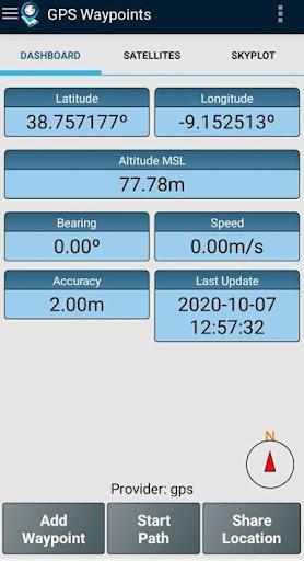
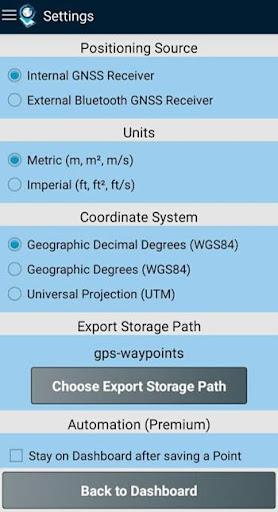
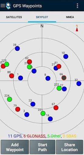
GPS Waypoints Screenshots


Top Download
More >


Trending apps
-

- HiAnime
- 4.3 Video Players & Editors
- HiAnime is the ultimate app for anime lovers. Whether you're a seasoned otaku or new to the anime scene, HiAnime offers an exceptional streaming experience. Dive into our vast library featuring popular series, timeless classics, and undiscovered gems, ensuring you catch every latest episode and belo
-

- Gallery - Album, Photo Vault Mod
- 4.3 Tools
- Gallery - Album, Photo Vault: Your Ultimate Photo Management SolutionGallery - Album, Photo Vault is a comprehensive app designed to simplify your photo and video management experience. It empowers you to easily locate, organize, edit, and protect your precious memories. Effortless Organization: Qui
-

- Amipos
- 4.2 Photography
- Introducing Amipos, the ultimate mobile app for all your sales needs. Designed to be simple and efficient, Amipos allows you to easily manage and collect payments from Amipass customers right from your phone. With Amipos, you can quickly track your monthly sales, view recent transactions, and even r
-

- Voices Talent Companion
- 4.5 Productivity
- The Voices Talent Companion app is a powerful tool for existing Voices website account holders. With over 2 million registered users, Voices is a marketplace that connects you with potential clients and job opportunities. Whether you're a freelancer or looking to expand your business, Voices intelli
-

- Gspace
- 3.4 Tools
- Unlock the Power of Google Apps on Huawei Devices with Gspace APK Gspace APK is a revolutionary mobile application designed to provide seamless access to Google services on Huawei smartphones and other Android devices lacking Google Mobile Services (GMS). Developed by the Gspace Team, this Android t
-

- Ocean Secure VPN Proxy Browser
- 4 Tools
- Ocean Secure VPN Proxy Browser: Your Secure and Private Gateway to the Web This Android app offers a user-friendly and secure browsing experience with unlimited free VPN proxy access. Protecting your data and privacy is paramount, and Ocean Browser achieves this by encrypting your internet traffic,
Latest APP
-

- CV VTuber Example
- 4.5 Tools
- Have you ever dreamed of becoming a virtual YouTuber? The CV VTuber Example app lets you take control of a 3D humanoid model directly through your webcam. Adjust the model's head orientation and facial expressions to bring your unique virtual person
-

- Printer - BlueTooth Thermal Pr
- 4.1 Tools
- Enjoy seamless wireless printing with Printer - Bluetooth Thermal Printer, an innovative app that connects your devices to thermal printers via Bluetooth technology. Skip the hassle of tangled wires and complex setups—simply tap your screen to print
-

- Slow Motion Video Camera
- 4 Tools
- Unleash your creativity and elevate your videos with the ultimate Slow Motion Video Camera app! Whether you want to slow down a captivating moment or speed up an exhilarating scene, this app has got you covered. With a wide range of speeds to choose
-

- FontSpace - Fonts Installer
- 4.4 Tools
- Looking to add unique flair to your projects with fresh fonts? The FontSpace - Fonts Installer app is your ultimate resource! It offers an extensive collection of free, stylish fonts—ideal for designers, bloggers, and social media enthusiasts. Downl
-

- Chat Partner - Random Chat
- 4.2 Tools
- Discover meaningful connections with Chat Partner - Random Chat, your gateway to exciting social interactions. Whether you're seeking casual conversations or meaningful relationships, our intuitive platform provides anonymous chatting in a secure en
-

- TrapCall: Unmask Blocked & Private Numbers
- 4.5 Tools
- Tired of getting harassing calls from blocked or unknown numbers? Discover the TrapCall: Unmask Blocked & Private Numbers app. Subscribe and install the app to reveal hidden callers and stop the frustration of unidentified calls. This app offers pow
-

- FetcherX Bookmarks (Tumblr Twitter video backup)
- 4.5 Tools
- FetcherX Bookmarks (Tumblr Twitter video backup) is a powerful application that enables you to save articles and images from any website with a simple long-press gesture. You can subscribe to your preferred Twitter, Tumblr, and Instagram accounts, a
-

- Bee Hive Monitoring Gateway
- 4.4 Tools
- Looking to keep a close eye on your bee hives but don't have the necessary hardware gateway? Look no further than the Bee Hive Monitoring Gateway app! This mobile gateway allows you to easily monitor the activity of your bee hives right from your sma
-

- Echofon for Twitter
- 4 Tools
- Elevate your Twitter experience with an intuitive and feature-packed app that keeps you connected anytime, anywhere. Meet Echofon for Twitter - the ultimate social media companion for Android and iOS devices. This powerful app combines a sleek desig