Home > Apps > Maps & Navigation > スーパー地形 - GPS対応地形図アプリ

Super Terrain: Your Comprehensive Mapping and Navigation App
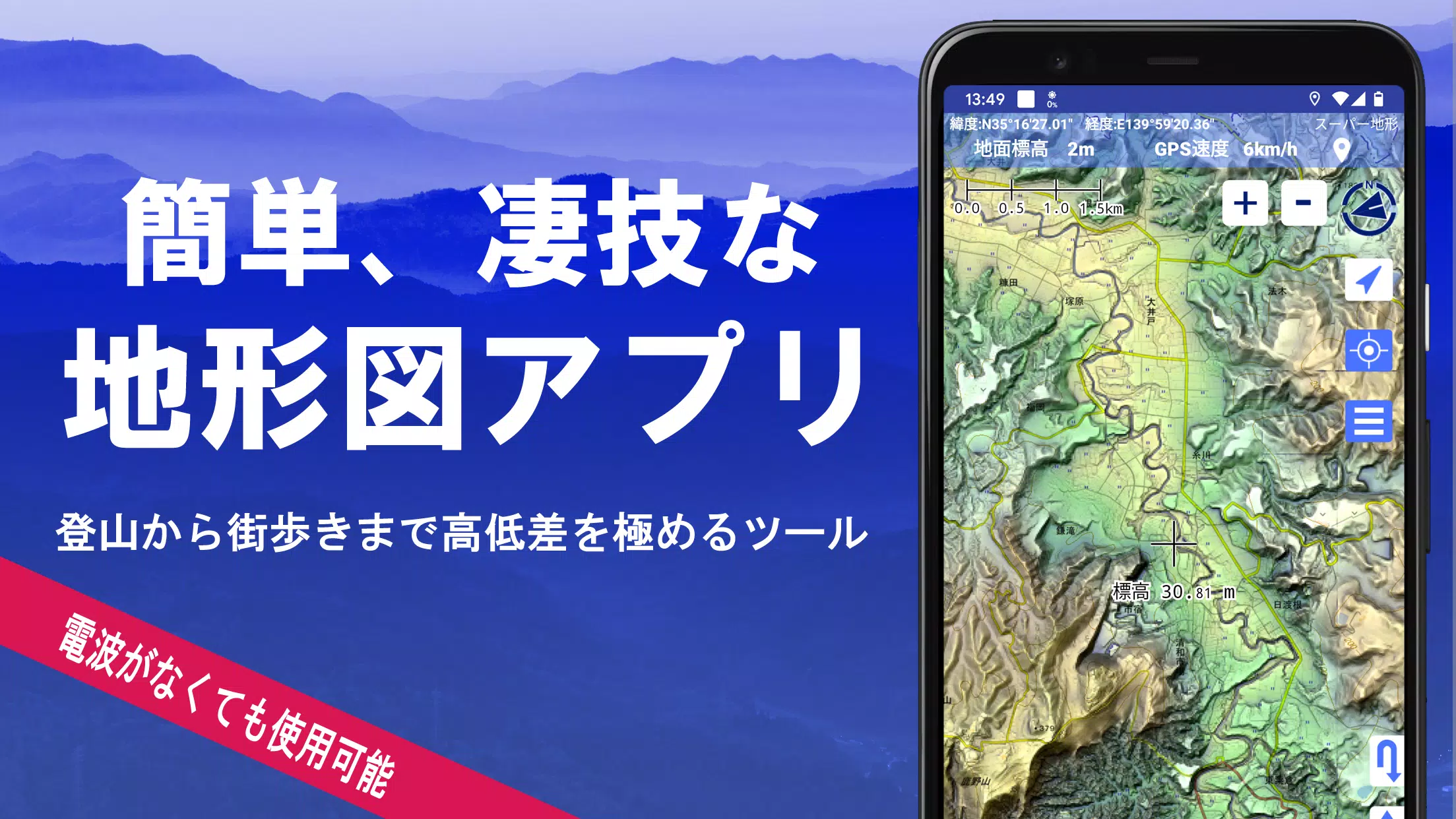
Super Terrain is a powerful mapping application boasting over 100 map types, including those from the Geospatial Information Authority of Japan (GSI). This award-winning app (recipient of the 2018 Japan Cartographic Society Award) leverages unique technology to provide detailed terrain data, perfect for everything from urban exploration to challenging mountain climbs.
Key Features:
-
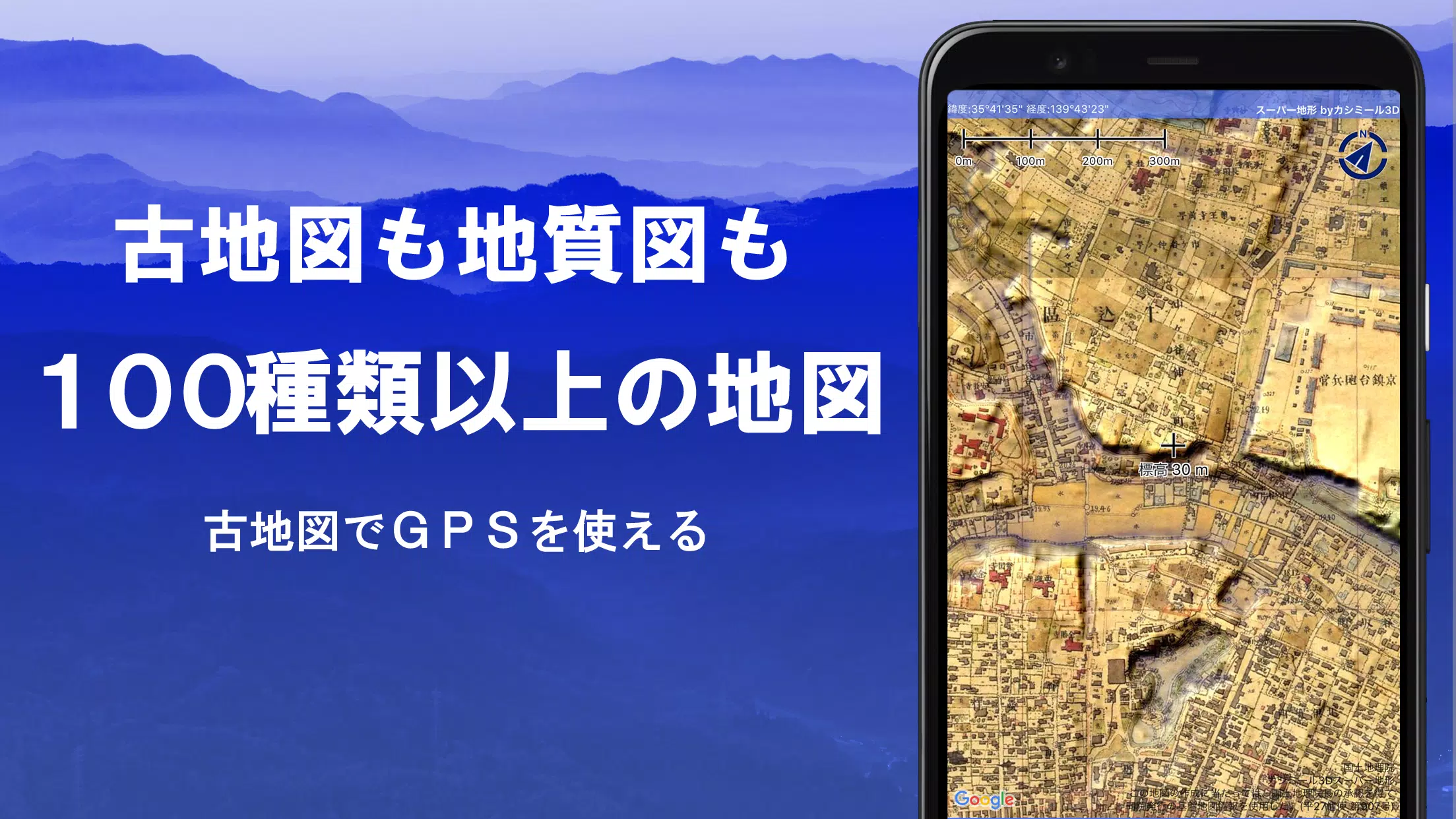
Extensive Map Selection: Access a vast library of maps, including GSI maps (topographic, geological, historical), and unique "super terrain data" for enhanced elevation detail. Aerial photographs are available (coverage varies by age). A 5-day free trial of super terrain data is included.
-
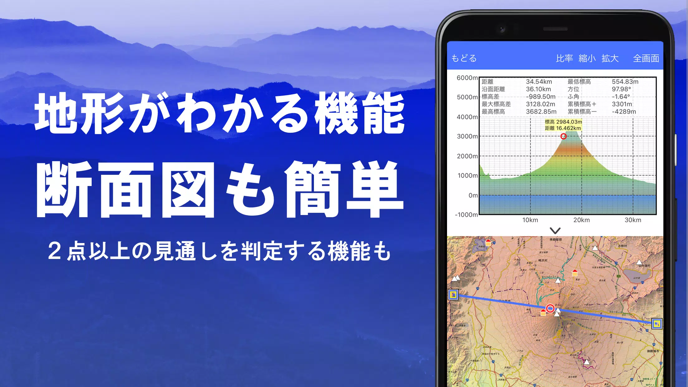
Advanced Terrain Analysis: Create precise cross-sections, assess visibility (considering Earth's curvature and atmospheric conditions), and incorporate building data where available. Ideal for route planning, radio communication analysis, and understanding complex terrain.
-
Interactive 360° Panoramic Views: Identify mountains, visualize sun and moon positions (useful for tracking celestial events like Diamond Fuji), and pinpoint GPS locations. This functionality extends to international locations.
-
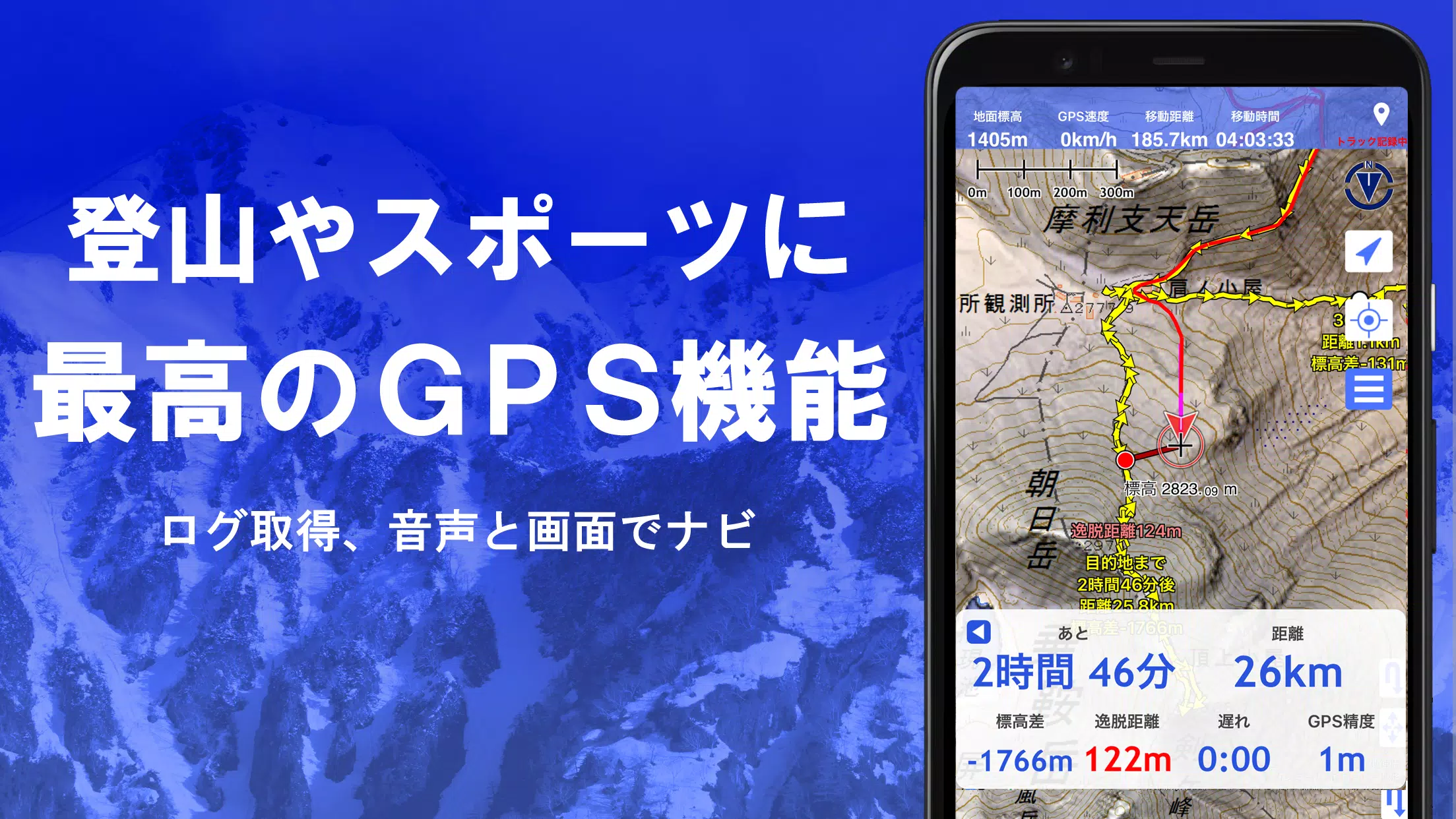
Robust GPS Functionality: Record high-precision tracks (GPX import/export supported), utilize audio GPS navigation (including off-track alerts), and manage points of interest with associated photos. The app includes track playback with photo synchronization.
-
Offline Capabilities: Download maps in bulk for offline use, ensuring seamless navigation even in areas without cellular or Wi-Fi connectivity. A map caching feature further enhances offline functionality.
-
Data Management & Editing: Edit GPS data (points, routes, tracks), organize data using folders, and create tracks directly on the map. GeoJSON data is fully supported, allowing for the import, display, and editing of GIS data. Shape drawing is also available.
-
Additional Features: Elevation palette customization, MGRS/UTM grid display, map printing and PDF output, dark theme support, map history, custom map compatibility, and data backup (including automatic backups via Google Drive).
Pricing & Availability:
Super Terrain offers a 5-day free trial. After the trial, a yearly subscription of 780 yen unlocks full functionality, including access to super terrain data, advanced GPS features, and cross-sectional views. The number of place name search results also increases with a paid subscription. Subscription management and cancellation are easily handled through Google Play. Note that prices may be adjusted in the future.
Important Considerations:
- Continuous GPS use impacts battery life; consider carrying a spare battery, especially during extended outdoor activities.
- Some smartphones may experience track recording interruptions due to power-saving features.
- The app's developers assume no responsibility for the outcomes of its use. Please refer to the user manual for complete details.
Download Super Terrain today and experience unparalleled mapping and navigation capabilities!
Navigation Function Guide (PDF): https://www.kashmir3d.com/online/superdemapp/superdem_navi.pdf
Additional Game Information
Latest Version4.6.17 |
Category |
Requires AndroidAndroid 5.0+ |
Available on
|

スーパー地形 - GPS対応地形図アプリ Screenshots


Trending apps
-

- HiAnime
- 4.3 Video Players & Editors
- HiAnime is the ultimate app for anime lovers. Whether you're a seasoned otaku or new to the anime scene, HiAnime offers an exceptional streaming experience. Dive into our vast library featuring popular series, timeless classics, and undiscovered gems, ensuring you catch every latest episode and belo
-

- Gallery - Album, Photo Vault Mod
- 4.3 Tools
- Gallery - Album, Photo Vault: Your Ultimate Photo Management SolutionGallery - Album, Photo Vault is a comprehensive app designed to simplify your photo and video management experience. It empowers you to easily locate, organize, edit, and protect your precious memories. Effortless Organization: Qui
-

- Amipos
- 4.2 Photography
- Introducing Amipos, the ultimate mobile app for all your sales needs. Designed to be simple and efficient, Amipos allows you to easily manage and collect payments from Amipass customers right from your phone. With Amipos, you can quickly track your monthly sales, view recent transactions, and even r
-

- Voices Talent Companion
- 4.5 Productivity
- The Voices Talent Companion app is a powerful tool for existing Voices website account holders. With over 2 million registered users, Voices is a marketplace that connects you with potential clients and job opportunities. Whether you're a freelancer or looking to expand your business, Voices intelli
-

- Gspace
- 3.4 Tools
- Unlock the Power of Google Apps on Huawei Devices with Gspace APK Gspace APK is a revolutionary mobile application designed to provide seamless access to Google services on Huawei smartphones and other Android devices lacking Google Mobile Services (GMS). Developed by the Gspace Team, this Android t
-

- Ocean Secure VPN Proxy Browser
- 4 Tools
- Ocean Secure VPN Proxy Browser: Your Secure and Private Gateway to the Web This Android app offers a user-friendly and secure browsing experience with unlimited free VPN proxy access. Protecting your data and privacy is paramount, and Ocean Browser achieves this by encrypting your internet traffic,
Latest APP
-

- BlueFire Apps
- 2.8 Maps & Navigation
- BlueFire Apps: Your Mobile Dashboard for Trucks, Boats, and RVs BlueFire Apps seamlessly integrates with your truck, motorhome, yacht, or other vehicle via the BlueFire Data Adapter. This adapter connects to your vehicle's 9-pin or 6-pin diagnostic port, transmitting J1939 and J1708 data to the app
-
- Phone Tracker GPS GeoPoint360
- 3.6 Maps & Navigation
- GeoPoint360: Real-time GPS Tracking for Peace of Mind GeoPoint360 offers reliable real-time GPS tracking, allowing you to monitor the location of loved ones and track important movements with confidence. Its core function is locating individuals using their phone numbers, providing real-time locati
-

- Cowboy
- 3.2 Maps & Navigation
- Experience the ultimate urban e-bike: The Cowboy. Connect, move, and stay safe with our intuitive app. Seamless Connectivity: Smart Navigation: Explore your city effortlessly. Find your favorite spots, bike parking, and even avoid congested areas. Real-time air quality maps help you choose the bes
-

- Otobüsüm Nerede
- 4.2 Maps & Navigation
- Istanbul's Public Transportation Made Easy with "Where Is My Bus?" The "Where Is My Bus?" app, a vital tool for navigating Istanbul's public transportation system, boasts a refreshed, user-friendly interface and enhanced infrastructure. Officially developed by the Istanbul Metropolitan Municipality
-
- SchoolBus
- 4.9 Maps & Navigation
- AVLView School Bus Module: Real-time GPS Tracking for Parents AVLView's highly anticipated School Bus module is finally here! This parent-focused app, accessible via app.avlview.com, empowers schools to manage bus schedules, assign pickup and drop-off locations, and provide parents with real-time u
-
- GPS, Maps, Voice Navigation
- 4.9 Maps & Navigation
- Experience effortless navigation with real-time traffic updates, offline maps, and voice-guided directions. This comprehensive navigation app is your ultimate travel companion, whether you're driving, walking, or cycling. Key Features: Advanced Mapping & GPS: Benefit from highly detailed maps and
-

- Radarbot Speed Camera Detector
- 3.2 Maps & Navigation
- Safety First with Real-Time NotificationsRadarbot Speed Camera Detector is a cutting-edge mobile application designed to revolutionize your driving experience. This app offers a comprehensive suite of features aimed at enhancing your safety, promoting adherence to traffic regulations, and simplifyin
-

- Locus Map
- 4.2 Maps & Navigation
- Explore the great outdoors with Locus Map, your all-in-one navigation app for a seamless outdoor adventure. Whether hiking, biking, or geocaching, Locus Map provides comprehensive guidance. Start Your Adventure with the Perfect Map: Choose from a vast selection of offline maps worldwide. From hikin
-

- Crawfisher LE
- 4.4 Maps & Navigation
- This GPS navigation and trap management app, Crawfisher (LE), is specifically designed for crawfish and spiny lobster fishing. It simplifies the process of recording and navigating to trap locations, maximizing efficiency and catch rates. Key features include: adding and organizing trap locations